Hydro Technology Examples
A reality capture Digital Twin is created by frequently scanning the project site above & below ground, and below water across the entire lifecycle of the project. The pre-planning and design stage of the lifecycle includes site surveys, ortho-mosaics, topography maps, and Digital Surface Models (DSMs), of the proposed run-of-river (RoR) hydropower sites. AI technology classifies and redacts vegetation to reveal the “bare earth” resulting in Digital Terrain Models (DTMs) and Digital Elevation Models (DEMs) with contours needed for design and construction planning.
Digitally Remove Foliage
A large area is scanned using Unmanned Aerial Vehicles (UAVs) LiDAR, including upstream locations such as potential landslide risks that may impact downstream power plants. Adjacent power plant construction projects are readily scanned at the same time for optimal economies of scale.
During the construction phase, frequent UAV LiDAR scans capture the surrounding ground topography that it integrated with surrounding buildings under construction (headworks, powerhouse, spillways and transmission substations. LiDAR point clouds are exported into a variety of engineering CAD formats such as .dwg, .dxf, .shp, as needed by architects, engineers, construction subcontractors and quality inspectors. AI technology detects changes across all data-sets
Click Lower Right Corner, To UnMute, and Click Full Screen

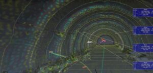
Digitize Tunnel – Extreme Detail and Speed
Multiple underground tunnels and vertical shafts, that descend hundreds of meters and span several kilometers, present an added level of complexity during construction. Accessibility, geological anomalies, and water seepage are challenges that create potential delays. For example, dam construction is dependent on and cannot begin until the diversion tunnels are fully operational. UAVs can be used in GPS-denied environments such as underground tunnels to measure construction quality, geological composition, and significant water seepage, which are added to the Digital Twin.
Click Lower Right Corner, To UnMute, and Click Full Screen
Digital Topography Survey
A large area is scanned using Unmanned Aerial Vehicles (UAVs) LiDAR, including upstream locations such as potential landslide risks that may impact downstream power plants. Adjacent power plant construction projects are readily scanned at the same time for optimal economies of scale.
During the construction phase, frequent UAV LiDAR scans capture the surrounding ground topography that it integrated with surrounding buildings under construction (headworks, powerhouse, spillways and transmission substations. LiDAR point clouds are exported into a variety of engineering CAD formats such as .dwg, .dxf, .shp, as needed by architects, engineers, construction subcontractors and quality inspectors. AI technology detects changes across all data-sets.
Click Lower Right Corner, To UnMute, and Click Full Screen
Tunnel Scanning
Tunnel construction projects are kept on-time by frequently scanning and analyzing “hot-spots” allowing experts to quickly remediate, apply design changes, and take corrective action.
All aspects of a complex hydroelectric project are integrated within the Digital Twin, including the headworks, tunnels, and powerhouse.
Click Lower Right Corner, To UnMute, and Click Full Screen
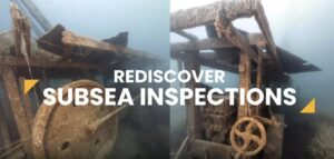
Water Scanning
Underwater features and components are scanned as well and included as port of the Digital Twin. Bottom scans of catchment ponds and spillways are recorded, monitored, and constantly analyzed.
Click Image For Additional Examples Of Water Management
Geotechnical Engineering
[click on image below, to navigate to geotechnical page]
What is Lorem Ipsum?
Lorem Ipsum
- Lorem Ipsum is simply dummy text of the printing and typesetting industry. Lorem Ipsum has been the industry’s standard dummy text ever since the 1500s
- Lorem Ipsum is simply dummy text of the printing and typesetting industry. Lorem Ipsum has been the industry’s standard dummy text ever since the 1500s
Lorem Ipsum
- Lorem Ipsum is simply dummy text of the printing and typesetting industry. Lorem Ipsum has been the industry’s standard dummy text ever since the 1500s
Lorem Ipsum
- Lorem Ipsum is simply dummy text of the printing and typesetting industry. Lorem Ipsum has been the industry’s standard dummy text ever since the 1500s
- Lorem Ipsum is simply dummy text of the printing and typesetting industry. Lorem Ipsum has been the industry’s standard dummy text ever since the 1500s
Lorem Ipsum
- Lorem Ipsum is simply dummy text of the printing and typesetting industry. Lorem Ipsum has been the industry’s standard dummy text ever since the 1500s
Lorem Ipsum
- Lorem Ipsum is simply dummy text of the printing and typesetting industry. Lorem Ipsum has been the industry’s standard dummy text ever since the 1500s
- Lorem Ipsum is simply dummy text of the printing and typesetting industry. Lorem Ipsum has been the industry’s standard dummy text ever since the 1500s
Lorem Ipsum
- Lorem Ipsum is simply dummy text of the printing and typesetting industry. Lorem Ipsum has been the industry’s standard dummy text ever since the 1500s